Grasping accuracy and precision#
Below, a small guide explaining what accuracy and precision are, and their relation to elevation data (or any spatial data!).
Why do we need to understand accuracy and precision?#
Elevation data comes from a wide range of instruments (optical, radar, lidar) acquiring in different conditions (ground, airborne, spaceborne) and relying on specific post-processing techniques (e.g., photogrammetry, interferometry).
While some complexities are specific to certain instruments and methods, all elevation data generally possesses:
a ground sampling distance, or footprint, that does not necessarily represent the underlying spatial resolution of the observations,
a georeferencing that can be subject to shifts, tilts or other deformations due to inherent instrument errors, noise, or associated processing schemes,
a large number of outliers that remain difficult to filter as they can originate from various sources (e.g., blunders, clouds).
All of these factors lead to difficulties in assessing the reliability of elevation data, required to perform additional quantitative analysis, which calls for defining the concepts relating to accuracy and precision for elevation data.
Accuracy and precision of elevation data#
What are accuracy and precision?#
Accuracy and precision describe systematic and random errors, respectively. A more accurate measurement is on average closer to the true value (less systematic error), while a more precise measurement has less spread in measurement error (less random error), as shown in the simple schematic below.
Note: sometimes “accuracy” is also used to describe both types of errors, while “trueness” refers to systematic errors, as defined in ISO 5725-1 . Here, we use accuracy for systematic errors as, to our knowledge, it is a more commonly used terminology for remote sensing applications.
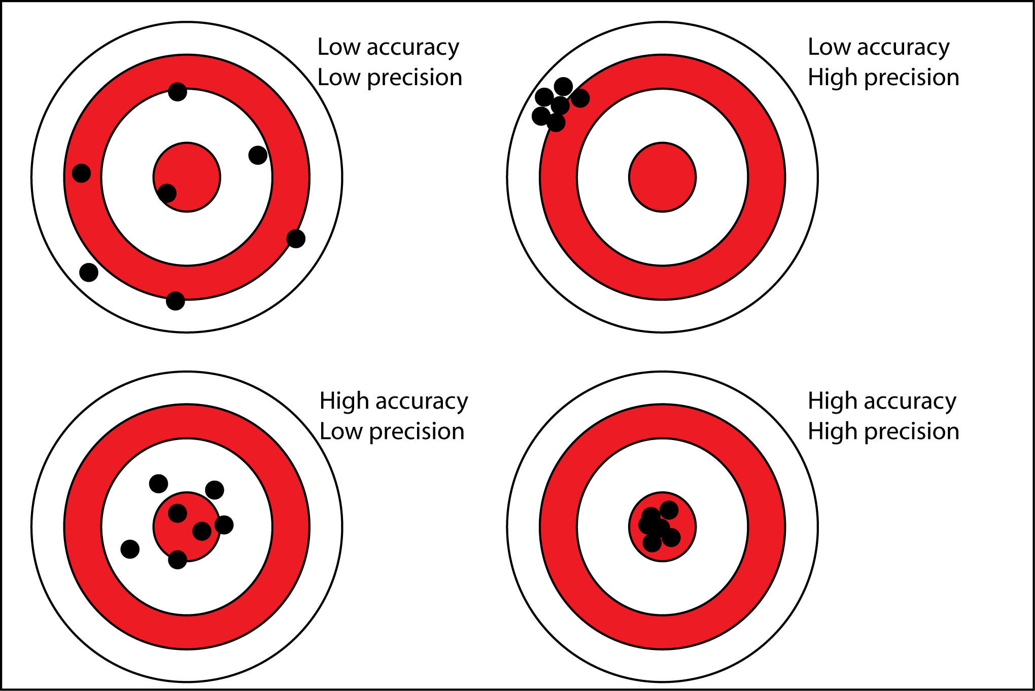
Source: antarcticglaciers.org, accessed 29.06.21.#
Translating these concepts for elevation data#
However, elevation data rarely consists of a single independent measurement but of a series of measurements (image grid, ground track) related to a spatial support (horizontal georeferencing, independent of height), which complexifies the notion of accuracy and precision.
Due to this, spatially consistent systematic errors can arise in elevation data independently of the error in elevation itself, such as affine biases (systematic georeferencing shifts), in addition to specific biases known to exist locally (e.g., signal penetration in land cover type).
For random errors, a variability in error magnitude or heteroscedasticity is common in elevation data (e.g., large errors on steep slopes). Finally, spatially structured yet random patterns of errors (e.g., along-track undulations) also exist and force us to consider the spatial correlation of random errors (sometimes called structured errors).
Translating the accuracy and precision concepts to elevation data, we can thus define:
Elevation accuracy (systematic error) describes how close an elevation data is to the true elevation on the Earth’s surface, both for errors common to the entire spatial support (DEM grid, altimetric track) and errors specific to a location (pixel, footprint),
Elevation precision (random error) describes the random spread of elevation error in measurement, independently of a possible bias from the true positioning, both for errors structured over the spatial support and specific to a location.
These categories are depicted in the figure below.

Source: Hugonnet et al. (2022).#
Absolute or relative elevation accuracy#
Accuracy is generally considered from two focus points:
Absolute elevation accuracy describes systematic errors to the true positioning, usually important when analysis focuses on the exact location of topographic features at a specific epoch.
Relative elevation accuracy describes systematic errors with reference to other elevation data that does not necessarily match the true positioning, important for analyses interested in topographic change over time.
How to get the best out of your elevation data?#
Quantifying and improving accuracy#
Misalignments due to poor absolute or relative accuracy are common in elevation datasets, and are usually assessed and corrected by performing three-dimensional elevation coregistration and bias corrections to an independent source of elevation data.
In the case of absolute accuracy, this independent source must be precise and accurate, such as altimetric data from ICESat and ICESat-2 elevations, or coarser yet quality-controlled DEMs themselves aligned on altimetric data such as the Copernicus DEM.
To use coregistration and bias correction pipelines in xDEM, see the feature pages on Coregistration and Bias correction.
Quantifying and improving precision#
While assessing accuracy is fairly straightforward as it consists of computing the mean differences (biases) between two or multiple datasets, assessing precision of elevation data can be much more complex. The spread in measurement errors cannot be quantified by a difference at single data point, and require statistical inference.
Assessing precision usually means applying spatial statistics combined to uncertainty quantification, to account for the spatial variability and the spatial correlation in errors. For this it is usually necessary, as for coregistration, to rely on an independent source of elevation data on static surfaces similarly.
To use spatial statistics for quantifying precision in xDEM, see the feature page on Uncertainty analysis.
Additionally, improving the precision of elevation data is sometimes possible by correcting random structured errors, such as pseudo-periodic errors (undulations). For this, one can also use Bias correction.
References and more reading
More background on structured random errors is available on the Spatial statistics for error analysis guide page.
References:
ISO 5725-1 (1994), Accuracy (trueness and precision) of measurement methods and results — Part 1: General principles and definitions,
Mittaz et al. (2019), Applying principles of metrology to historical Earth observations from satellites,
Hugonnet et al. (2022), Uncertainty analysis of digital elevation models by spatial inference from stable terrain,
ASPRS (2024), ASPRS Positional Accuracy Standards for Digital Geospatial Data, Version 2.